Ready to unlock the power of aerial environmental intelligence?

Lidar Technology to full-fill all your surveying needs


Our Mission
We are a consulting firm specializing in image data processing (Photogrammetry, LiDAR, GIS) for architectural, engineering, and construction projects.
Our team delivers top-quality solutions tailored to meet each client's specific needs, including accurate mapping services for construction projects.
One data mapping solution from scan to BIM


survey grade accuracy for LiDAR data
Innovation In Flight
We use state-of-the-art drones and AI-powered analytics deliver accurate, real-time data for informed environmental decisions


LiDAR + ORTHO + LINEWORK
Ideal for projects that require LiDAR and ortho deliverables with linework.
LiDAR
Service
Ideal for projects that require vegetation-filtered topos, including contours + TIN.
LiDAR
Data Deliverables
Includes:
De-noised LiDAR Point Cloud
DWG Files(or requested)
25' Ground Grid
LandXML
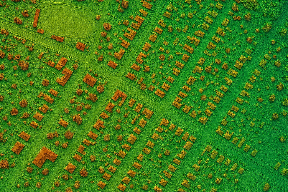
Survey-Grade LiDAR
Experience unmatched accuracy with our survey-grade LiDAR data collection. This technology captures precise geographic data, ideal for detailed land surveys and topographic mapping, crucial in planning and development.
Vegetation Filtering
By efficiently separating ground data from plant and tree cover, we can now successfully generate accurate topographic maps no matter the density of vegetation.
Workflow Integration
Workflow Integration
Optimize data management with workflow integration. Successfully import the data we send into the CAD or GIS program you and your team already use. Less hassle, more productivity.
LiDAR + ORTHO

Data Deliverables
Includes:
De-noised LiDAR Point Cloud
DWG Files(or requested)
25' Ground Grid
LandXML
Survey-Grade LiDAR & Photogrammetry
Experience unmatched accuracy with our survey-grade LiDAR and photogrammetric data collection. This technology captures precise geographic data, ideal for detailed land surveys and topographic mapping, crucial in planning and development.
High-Resolution Orthomosaics
Get a clearer picture. Whether it's for land development, construction planning, or environmental studies, orthomosaics serve as a reliable resource for making informed decisions. They merge precision with clarity, ensuring that every detail is captured and presented with the highest resolution.
Workflow Integration
No need to change your workflow. Optimize data management with workflow integration. Successfully import the data we send into the CAD or GIS program you and your team already use. Less hassle, more productivity.

Data Deliverables
Includes:
De-noised LiDAR Point Cloud
DWG Files(or requested)
25' Ground Grid
LandXML
Survey-Grade LiDAR & Photogrammetry
The accuracy you expect and need. Experience unmatched accuracy with our survey-grade LiDAR and photogrammetric data collection. This technology captures precise geographic data, ideal for detailed land surveys and topographic mapping, crucial in planning and development.
Precision Planimetrics
Get comprehensive understanding of a site’s physical characteristics with planimetrics and line work. We meticulously delineate boundaries, structures, roads, and vegetation, providing an invaluable layer of detail. Whether for urban planning, infrastructure development, or environmental management, planimetrics offer an essential foundation for precise, data-driven decision-making.
Workflow Integration
No need to change your workflow. Optimize data management with workflow integration. Successfully import the data we send into the CAD or GIS program you and your team already use. Less hassle, more productivity.
LiDAR + ORTHO + Line
Aerial Perspectives
Let's Elevate Your Data
Ready to unlock the power of aerial lidar intelligence? Contact us!